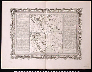
Map: Empire Ninus, Empire Sesostris
1991.18.0057
Detailed Images
Basic Information
| Artifact Identification | Map: Empire Ninus, Empire Sesostris (1991.18.0057) |
|---|---|
| Classification/ Nomenclature |
|
| Artist/Maker | Barbou, J. |
| Geographic Location | |
| Period/Date | 1777 CE |
| Culture | French - western; Ancient Rome |
Physical Analysis
| Dimension 1 (Width) | 66.7 cm |
|---|---|
| Dimension 2 (Height) | 49.9 cm |
| Dimension 3 (Depth) | 0.1 cm |
| Weight | 52 g |
| Measuring Remarks | None |
| Materials | paper |
| Manufacturing Processes | Printed |
| Munsell Color Information | Pale Yellow Green (5GY 9/1.5) -Mare indicum. Grayish Olive (5Y 3/2) -Picture frame border. Yellowish White (5Y 9/2) -Penninsula India. |
Research Remarks
| Published Description | N/A |
|---|---|
| Description | N/A |
| Comparanda | N/A |
| Bibliography | N/A |
Artifact History
| Archaeological Data | N/A |
|---|---|
| Credit Line/Dedication | The Seymour and Muriel Yale Collection of Coins of the Ottoman Empire and Other Middle East States |
| Reproduction | No |
| Reproduction Information | N/A |