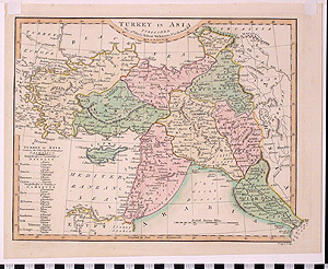
Map: Turkey in Asia
1989.11.0040
Detailed Images
Basic Information
| Artifact Identification | Map: Turkey in Asia (1989.11.0040) |
|---|---|
| Classification/ Nomenclature |
|
| Artist/Maker | Wilkinson, Robert |
| Geographic Location | |
| Period/Date | 1820 |
| Culture | British, English |
Physical Analysis
| Dimension 1 (Width) | 31.5 cm |
|---|---|
| Dimension 2 (Height) | 21.2 cm |
| Dimension 3 (Depth) | <0.1 cm |
| Weight | 137 g |
| Measuring Remarks | None |
| Materials | Paper--rag, Pigment--ink |
| Manufacturing Processes | Printed |
| Munsell Color Information | Green (7.5yr8/4) -ns Pink ( 5y8/3 5y8/1 5g7/2(approx)) -ns Yellow, white, brown ( 7.5r6/4(approx)) -ns Pale Pink (10rp 9/2)-pink (Syria) Very Pale Green (5g 8.5/2)-green (Turcomania) Yellowish White (5y 9/2)-Yellow (Algezira) |
Research Remarks
| Published Description | A well researched map of the region. This part of the Empire is divided up into what the cartographer translates as "Beilerbeglics" and "Pachalics" (from the Turkish titles "bey" and "pasha".) |
|---|---|
| Description | N/A |
| Comparanda | N/A |
| Bibliography | N/A |
Artifact History
| Archaeological Data | N/A |
|---|---|
| Credit Line/Dedication | The Seymour and Muriel Yale Collection of Coins of the Ottoman Empire and Other Middle East States |
| Reproduction | no |
| Reproduction Information | N/A |